Flooding in the Chao Phraya River basin caused by tropical depression Dianmu was averted thanks to good planning, said the Department of Royal Irrigation.
Thongplew Kongjun, the department's deputy chief, said Dianmu caused severe flooding in northern provinces last week, but the situation was now returning to normal as water levels in the Nan and Yom rivers were receding.
Moreover, no farming zones in the upper Chao Phraya River basin were affected by flooding due to cooperation between the department and state agencies to set up preventive measures, including installing water pumps to drain water from several farming zones in Sukhothai and Phichit provinces.
According to the department, water flow in the Nan River dropped from 2,412 cubic metres a second to 1,707 c/mecs on Monday, leaving the water level 0.53 metres lower than the river bank.
The carrying capacity of the Nan River is 1,506 cubic metres per second.
"It is clear the depression has not caused any flooding in the Chao Phraya River basin as the public had feared. We have big areas to keep water in Bang Rakam [district in Phitsanulok] and Pho Thale [district in Phichit] in the upper Chao Praya River that helps us deal with the situation when it arises," he said.
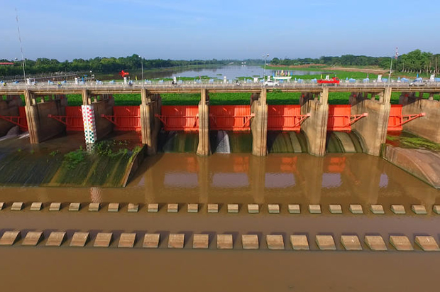
Mr Thongplew said water from the North could be also managed by the Chao Phraya dam in Chai Nat province, through which water could flow easily after the military cleared 55,000 tonnes of water hyacinth that had blocked water flow.
He said the military and the Department of Public Works and Town & Country Planning will survey the hyacinth situation in the Mae Klong and Tachin Rivers in the west of the country to clear them away before heavy rains which are expected to hit over the next two months.
He said the depression brought over 800 million cubic metres of water to the Sirikit dam in Uttaradit province and almost 100 million cubic metres to the Bhumibol dam in Tak province.
The four main dams along the Chao Praya River currently hold around nine billion cubic metres, of which 3.5 billion are reserved for yearly consumption.
Regarding the increasing water level of the Mekong River, Mr Thongplew insisted the level of water in the river was still 2.5-4 metres lower than the river bank, but local authorities in high-risk areas such as Nakhon Phanom and Mukdahan are on high alert to prevent flooding.