AYUTTHAYA - Waterside communities in Bang Ban, Phra Nakhon Si Ayutthaya and Sena districts were inundated and the flood was expanding to other districts on Friday as the Chao Phraya Dam increased its rate of discharge to accommodate run-off from the North.
The dam, in Chai Nat province, was releasing water at 1,503 cubic metres per second.
The level of big Bang Luang canal, which links the Chao Phraya River and the Noi River, rapidly rose and flooded nearby communities in Bang Ban district from about 8am on Friday. Waterside communities in Phra Nakhon Si Ayutthaya and Sena districts were also flooded.
Altogether about 1,800 families in 65 villages in the three districts were affected. Floodwater was 30-50 centimetres deep and was expected to rise to one metre.
Udomsak Khaonuna, provincial chief of disaster prevention and mitigation, said flooding was expanding to other districts next to the Chao Phraya and Noi rivers, including Bang Sai and Phak Hai districts.
Ayutthaya is the only low-lying province in the Chao Phraya river basin that does not have floodwalls.
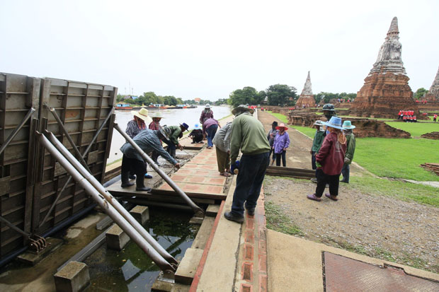
Officials of the Fine Arts Department started to raise knockdown flood walls at historical Wat Chaiwatthanaram in Phra Nakhon Si Ayutthaya district to protect the ancient buildings.
Prateep Phengtako, fine arts director in Ayutthaya, said the level of the Chao Phraya River by the temple was rising quickly, with only about 50cm remaining before overflow. The 200-metre-long knockdown flood walls could hold back flood levels at up to two metres, he said.
In Nakhon Sawan province, run-off from Mae Wong National Park has spread over more than 10,000 rai of farmland in three tambons of Mae Wong district.
The flood on Friday reached the economic zone of Lat Yao district with an average depth of 20-30 centimetres and was expected to keep rising as more water flowed down from forested hills.
Chatchai Phromlert, director-general of the Department of Disaster Prevention and Mitigation, said flooding and landslides were reported in parts of Ayutthaya, Chaiyaphum, Kamphaeng Phet, Kanchanaburi, Nong Bua Lam Phu, Phangnga, Phetchabun and Sukhothai provinces.
He also warned of possible flooding and landslides in the southern provinces of Nakhon Si Thammarat, Phangnga and Surat Thani, where there has been continuous rain.

The water from Mae Wong National Park has reached the economic zone in Mae Wong district on Nakhon Sawan province. (Photo by Chalit Phumruang)