Five buildings on the route leading to Phu Chi Fah mountain peak, one of the most famous tourist destinations in Chiang Rai, have collapsed following a landslide triggered by week-long rains.
Provincial authorities have declared the area a disaster zone.
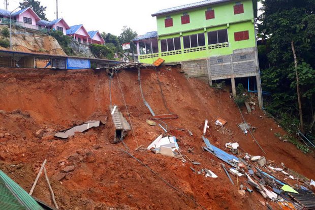
No one was hurt in the incident, which happened Tuesday on the route leading to Phu Chi Fa in Thoeng district.
The five concrete buildings on Highway 1093 in Ban Rom Fa Thai in tambon Tap Tao were destroyed. The building owners were unharmed, but were unable to remove their belongings in time.
Another four buildings nearby are also at risk of collapse, as is a two-storey tourist information centre.
A 100-metre section of the area has been closed to traffic while authorities allow residents in nearby buildings to remove their belongings.
Thoeng district chief Niwat Ngamtura said torrential rains, which have lasted for more than seven days, led to the landslide.
The area has been battered with up to 99 millimetres of rain a day over the course of the past three days, he said.

The estimated damage was put at 1.2 million baht, Mr Niwat said. Chiang Rai Highway District 2 plans to erect a bridge over the collapsed road to make it temporarily passable to motorists.
A road survey will be conducted over the next few days before the repair work commences, he noted.
Before the collapse took place, nine villages, including landslide-affected Ban Rom Fa Thai, had been warned over the possibility of landslips.
In Mae Sai district, at least 500 houses were inundated by flood water pouring out of Tham Luang-Khun Nam Nang Non forest park after several consecutive days of heavy downpours.
The forest park is home to Tham Luang cave, where 12 young footballers and their coach were trapped following floods inside the system on June 23 and successfully extracted from July 8-10.
Rescue workers have been sent to assist flood victims, some of whom were trapped inside their houses by the rising water, said Mae Sai district chief Somsak Khanakham.
The flood-ravaged areas are in tambons Pong Pha and Pong Ngam. A two-kilometre inbound section of the Chiang Rai-Mae Sai Road was also closed to traffic, with floodwater reported to be about 80 centimetres deep in places.
Meanwhile, the Mekong River has burst its banks and swamped low-lying areas of the northeastern provinces of Nong Khai, Bung Kan, Nakhon Phanom, Mukdahan and Ubon Ratchathani, according to Royal Irrigation Department chief Thongplew Kongjun.
In Nakhon Phanom, the flood situation was exacerbated by the Kam River overflowing and flooding 50 homes in Ban Pak Bang of tambon Phi man of Na Kae district.
Lao authorities have also warned local residents to brace for possible flooding as the Nam Ngum dam is set to discharge more water.
The discharge would increase the level of Ngum River, which connects with the Mekong River in Nong Khai's Phon Phisai district
In Khon Kaen province, runoff from Phu Phan mountain range and Kalasin has inundated large areas of farmland in tambons Kokmuang and Nonchaisri of Phon Thong district.