At the front end of a long wooden boat, I stood up to appreciate the full view of the natural world around me. There weren't as many lotus blossoms to be seen as in my previous visits years ago but the peaceful marshland was still full of life. A variety of plants and animals were still celebrating the life-giving rain that had stopped just a few minutes ago. It's hard to believe that in 2016 this very place became so dry that you could see the cracked soil surface. I hope that will never happen again.


Thung Sam Roi Yot marshland on the west side of its namesake mountain range is home to a vast diversity of flora and fauna. However, it is best known among tourists for its lotuses and water lilies. While the blooms of these aquatic plants can be enjoyed throughout most of the year, the peak period is from October to January. If the lotuses and water lilies are your priorities, the best time of day to visit the wetlands is during the morning hours when the Sun is not too strong and the flowers open up their petals to greet the sunlight and pollinators. The evening is when rest time begins and most water lilies and lotuses do not blossom. However, the atmosphere is blissful in the late afternoon, especially after the rain — unless you stay too late and the mosquitoes find you — as there are birds and other interesting things to see. Speaking of birds, Thung Sam Roi Yot is a major birdwatching site, especially in the cool season when the wetland and the rest of the national park is visited by many migratory species. Most of the photographs shown here were taken on a recent evening but one of them was from a morning in 2007. With the hint provided, can you guess which one it is?
Anyway, as always, not so far in the background is the iconic jagged-top of the Khao Sam Roi Yot mountain range which lends its name to both the national park and this district of Prachuap Khiri Khan province where it is located. Taking a deep breath of the refreshing air, I felt so good to be back in this wonderful place.
The next morning, my friends and I set off for a tour of Khao Sam Roi Yot National Park. Our first stop was the Khao Daeng scenic lookout point which was close from where we were. However, it's a pity we didn't have time to check out the nature trail at the back of the park's headquarters nearby.
After climbing down from the hilltop viewpoint, we rushed to Ban Bang Pu for a quick early lunch. After that, we hiked over the headland to Laem Sala Beach and set off for the day's longest climb to Phraya Nakhon Cave.
Despite our best efforts in the race against time, we were too late to catch a glimpse of the magical moment when the Sun's beams fall directly into the main chamber of the cave. Yet, as I stood in front of the majestic royal pavilion inside the big cave -- an easy stone's throw from the spot where my high school friends and I took group photos 35 years ago -- I couldn't help feeling elated to be there once again.
On the way back to Bangkok, I was so exhausted that I slept most of the way. Next time, I should go there for a vacation instead of for work so I can have more time to spend in the park, which is one of my all-time favourites.

Hat Laem Sala, from where the hiking trail to Phraya Nakhon Cave begins, is inaccessible by road. The beach can be reached either by boat from the fishing village of Ban Bang Pu or by climbing over a headland that separates it from the beachfront of the village. Of course, the boat ride is more convenient. However, if you’re in good health and do not have tents or other heavy loads to carry, the short hike is not too bad. It gives you a chance to enjoy a panoramic view of the sea and the coastline. If your destination is Phraya Nakhon Cave, you’ll have to walk from Laem Sala Beach anyway. Another good option is to climb the headland on the first leg and take the boat during the return leg. It’s wise to inform a boatman at Laem Sala of your intentions before you start the hike from there to the cave.

Thung Sam Roi Yot plays a crucial role in the well-being of families living on its fringes. The wetland is not just a source of extra income from tourists using the boat service that the villagers provide but also their source of food. My boatman, Men, also took me and my friend to the sites where he had laid fish traps. His catch that evening included a blackchin tilapia (Sarotherodon melanotheron or pla mo si khang dam in Thai) which is an aggressive omnivorous alien species. This is proof that despite conservation efforts and the beautiful pictures, the health of the marshland is still under threat and locals are a crucial part of the ecology and its preservation.


Khao Sam Roi Yot is home to different types of habitats and thus a long list of plant species. Perhaps, the toughest of them all are those that occupy the rocky parts of the park’s limestone mountains. With no soil to hold nutrients and no other source of water except for rain, many species, including chan pha (Dracaena cochinchinensis) and a number of cacti have no problem thriving. My utmost respect for these hardy survivors!


At the village of Ban Bang Pu, apart from observing the daily life of local fishermen, you can also find a number of seafood restaurants. No matter which one you drop by, make sure you order pla muek daet dieo, which is made of squid that is half-dried in the sunshine before being deep-fried. It’s the area’s speciality.


Despite its hidden location, which requires a 430m hike to reach and has a number of steep sections, Tham Phraya Nakhon was visited by five monarchs of the Chakri Dynasty, including King Rama V who had a traditional Thai-style pavilion created in Bangkok and assembled in the cave’s main chamber 130 years ago. The Khuha Kharuhat Pavilion, regarded as a symbol of Prachuap Khiri Khan province, is not the only highlight of Tham Phraya Nakhon. The beauty of the cave itself was what attracted the kings and countless other travellers in the first place. If you wish to see the Sun’s rays shine through the opening on the chamber’s ceiling, you should make it there from 10.30am to noon. According to the park’s ranger stationed in the cave, the best time to see the light fall directly onto the pavilion is in October.
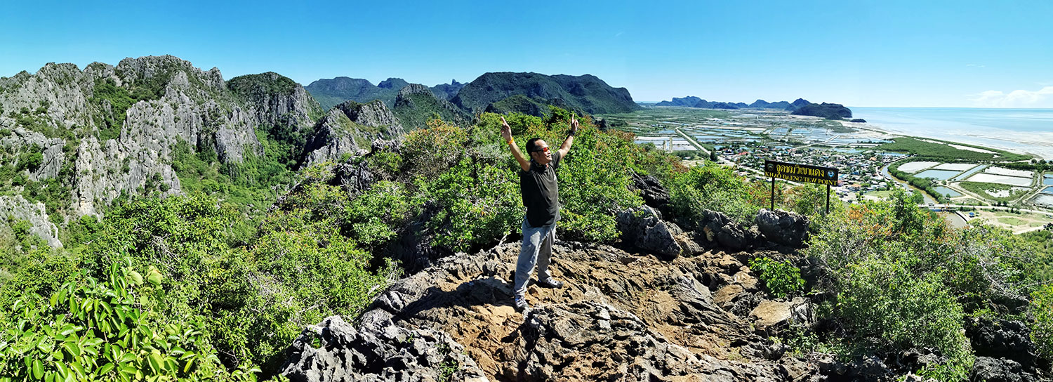

From the lookout point at the top of Khao Daeng, you can soak in the vista of the national park’s coastal area and nearby karst formations. This trail is shorter than the one to Phraya Nakhon Cave, measuring around 300m, but steeper. It is recommended that you climb this hill in the morning before the Sun is too strong. Further east along the park’s main road, not so far from the trailhead is Klong Khao Daeng, a natural waterway lined with mangrove vegetation. At Wat Khao Daeng, you can take a boat tour of the river.

Khao Sam Roi Yot National Park earned its status in 1966, the fourth after Khao Yai, Phu Kradueng and Doi Inthanon. However, it was the Kingdom’s first marine national park. If that didn’t happen, perhaps this undisturbed Hat Laem Sala would have not been so much different from those in Pran Buri or Hua Hin, which are not too far away to the north. Apart from Hat Laem Sala, Hat Sam Phraya, which is closer to Khao Daeng and the park’s headquarters, is another beach where visitors are allowed to camp. Scanning Google Maps, you’ll find a couple of secret beaches which are likely to be in near-pristine condition along the mountainous shoreline. Two of them are within kayaking distance south of Hat Laem Sala.


This protected area boasts a rich diversity of animals, from tiny ones like insects and crustaceans to fish, birds and mammals as large as the serow. However, the park’s most common mammals are the spectacled langur (also called dusky leaf monkey) and the crab-eating macaque. The first is a gentle, peace-loving animal and they can be found along the trails to Khao Daeng lookout point, Hat Laem Sala and Tham Phraya Nakhon. The naughty macaques live in mangrove areas.


Exploring Khao Sam Roi Yot’s attractions is almost hassle-free. The national park has at the ready facilities and services provided both by the park itself and by communities in the area from boat services at Bueng Bua, Klong Khao Daeng and Ban Bang Pu to well-marked trails, safe camping areas and clean toilets.
TRAVEL INFO
- Khao Sam Roi Yot National Park is about 60km south of downtown Hua Hin. The park's visitor centre, which is located at the southern end of the Sam Roi Yot mountain range and is not far from the trailhead to the Khao Daeng lookout point shown in the accompanying map, can be reached both from the west and east sides of the range.
- Since the park's attractions are pretty far apart, the most convenient way to get around is by private vehicle. If you don't feel like driving from home, you can rent a car or a motorcycle in Hua Hin and drive from there. Another option is to take a public bus to Pran Buri town and a songthaew to Ban Bang Pu, the gateway to Laem Sala and Tham Phraya Nakhon. However, this will take a lot more time and will not get you to other parts of the park unless you manage to hire somebody to take you around. For more information about the park, visit its Facebook page.
- Also, to help the park keep the number of visitors within its daily capacity and ensure you're not denied entry, don't forget to download the QueQ app and book your visit before the day you plan to show up.

